
 When someone feels comfortable making such a pointed statement in their openning remarks, I just have to quote them and blog them.
In this talk on mars historic river systems, Ted Maxwell presented a visually stunning story rich with labeled MOC images. This is a bloggers dream come true – I can actually find what he said! Scientists out there reading – If you use archive data with filenames, please include the names on the overhead! Now, all that said, I’m suddenly realizing Malin changed their interface since the last time I used it, and I can’t find images by ID. Eek! Clearly I need to talk to Emily…
Anyway, back to science.
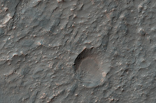
Basic story: Once upon a time on Mars, during a far distant epoch no one gave a date to, it rained on Mars. Like on Earth, this rain washed across the land, filling drainage ditches that merged into streams, that merged into bigger bodies, sometimes even filling basins (also called craters – it all depends on what you use them for). In some cases, these basins even overflowed, creating new stream and gully systems. One example is Durius Vallis. Overflows were also found in Terra Cimmeria. The scientists studying these systems used the area of the region covered in gully networks and to determine what it took to fill the basins/craters. They found that in some cases the area that fed a basin was 15 times larger than the surface area of the basin! The basin above (image credit: NASA/JPL/University of Arizona) is Eberswalde Crater and is an example.
Calculating the exact volume of these basins/craters turned lakes in the modern era is difficult. They are often overlaid with lava/dust/other stuff that modifies their floor and changes the altitude change between rim and floor. Nonetheless, they sink in some cases, like the Eberswalde delta at -1400m, geological formations seen today may record the paleolake levels. In this case, the lake area is 400 square kilometers, and the contributing area feeding it is 4800 square kilometers!
While no one piped up and offered a specific year range when liquid water appeared, they did work to bin the time frame using craters. They found that Small impact craters in the a Noachian crater floor in MOC R1001508 is etched but relatively well preserved. At the same time a southern crater shown in MOC E040005 is deeply etched with light-toned fractured material exposed by the etching. These are seen as possible basin deposits from wetter days.
It appears certain that these are ancient features. It is cool to image rain sweeping through the now dry frozen land scape. Can you imagine Meteor Crater in Arizona filling up with water and overflowing in rivers and streams that flood the surrounds? That’s what happened on Mars! And sometimes, the paleolakes – the craters filled with water, were interconnected as one basin flowed into another, as water flowed.
What a different world it was then!